Excursión A pie The Municipal District of Cahir — Cashel - Lough Muskry - Photo

Tous les sentiers balisés d’Europe GUIDE+

© OpenStreetMap contributors
Longitud
Longitud
4,4 km
Altitud máxima
Altitud máxima
501 m
Desnivel positivo
Desnivel positivo
16 m
Km-Effort
Km-Effort  
5,8 km
Altitud mínima
Altitud mínima
136 m
Desnivel negativo
Desnivel negativo
376 m
Boucle
Boucle
No
Baliza
Baliza
Fecha de creación :
2025-02-06 12:59:01.935
Última modificación :
2025-02-06 12:59:01.935

(0 Opinión)

A pie
A pie
1h19
Dificultad : Fácil

Escanee este código QR para abrir la excursión en la aplicación SityTrail

Aplicación GPS de excursión GRATIS

Logo SityTrail SityTrail

IGN / Institutos geográficos

Descargar SityTrail en App Store Descargar SityTrail en Google Play

Logo SityTrail SityTrail World

El mundo es suyo

Descargar SityTrail en App Store Descargar SityTrail en Google Play Descargar SityTrail en Huawei AppGallery

A propósito

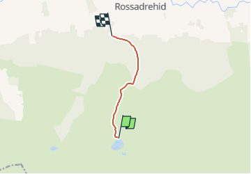
Ruta A pie de 4,4 km a descubrir en Desconocido, County Tipperary, The Municipal District of Cahir — Cashel. Esta ruta ha sido propuesta por SityTrail - itinéraires balisés pédestres.

Perfil altimétrico

Fotos

Localización

País:
Ireland
Región :
Desconocido
Departamento/provincia :
County Tipperary
Municipio :
The Municipal District of Cahir — Cashel
Localidad:
Templeneiry
Salida:(UTM)
559923 ; 5803177 (29U) N.

Excursiones cerca

Excursión Senderismo The Municipal District of Cahir — Cashel - l diheen - Photo
Senderismo
mlmoroneybb

Senderismo

Difícil
The Municipal District of Cahir — Cashel, Desconocido, County Tipperary, Ireland
16,3 km | 32 km-effort
5h 46min
Excursión Senderismo The Municipal District of Cahir — Cashel - Galtees - Lake Muskry Circuit - Photo
Senderismo
johnkeating

Senderismo

Muy fácil
The Municipal District of Cahir — Cashel, Desconocido, County Tipperary, Ireland
10,1 km | 18,2 km-effort
3h 10min
No
Excursión Senderismo The Municipal District of Cahir — Cashel - Lough Borheen  - Photo
Senderismo
mlmoroneybb

Senderismo

Difícil
The Municipal District of Cahir — Cashel, Desconocido, County Tipperary, Ireland
12,6 km | 19,8 km-effort
Desconocido
No
Excursión Senderismo The Municipal District of Cahir — Cashel - 14-FEB-10 - Photo
Senderismo
mlmoroneybb

Senderismo

Difícil
The Municipal District of Cahir — Cashel, Desconocido, County Tipperary, Ireland
10,9 km | 19,6 km-effort
Desconocido
Excursión Senderismo The Municipal District of Cahir — Cashel - Galtee Mountains - Photo
Senderismo
mlmoroneybb

Senderismo

Difícil
The Municipal District of Cahir — Cashel, Desconocido, County Tipperary, Ireland
15,9 km | 30 km-effort
Desconocido
No
Excursión Senderismo The Municipal District of Cahir — Cashel - Galtee Mountains - Photo
Senderismo
mlmoroneybb

Senderismo

Muy difícil
The Municipal District of Cahir — Cashel, Desconocido, County Tipperary, Ireland
15,9 km | 30 km-effort
Desconocido
No
Excursión Vía ferrata The Municipal District of Cahir — Cashel - Galtymore Horse shoe - Photo
Vía ferrata
mlmoroneybb

Vía ferrata

Difícil
The Municipal District of Cahir — Cashel, Desconocido, County Tipperary, Ireland
13,7 km | 27 km-effort
Desconocido
Excursión Senderismo The Municipal District of Cahir — Cashel - Lough Borheen  - Photo
Senderismo
mlmoroneybb

Senderismo

Muy fácil
The Municipal District of Cahir — Cashel, Desconocido, County Tipperary, Ireland
12,6 km | 19,8 km-effort
Desconocido
No
Excursión Senderismo The Municipal District of Cahir — Cashel - Galtee Walkers B Walk Sunday 17 October 2010 - Photo
Senderismo
johnkeating

Senderismo

Muy fácil
The Municipal District of Cahir — Cashel, Desconocido, County Tipperary, Ireland
8,8 km | 13,8 km-effort
3h 1min


Cerrar
Mis suscripciones